Statue on the east side of the Codz Poop, Kabah. Photo by Joshua Albers, May 23, 2015.
After a full morning at Uxmal (and much needed siesta at the Pickled Onion), we drove south-east to our next stop on the Ruta Puuc: Kabah.
As one of Uxmal’s closest and largest neighbors, Kabah was once connected to the larger city by means of a 30 km sacbe. Today, Highway 261 unites the sites. Visitors park on the west side of the modern road, then cross to pay the entrance fee and explore the remains of two palace-style structures.
View of Kabah’s east side. The Codz Poop is partially visible on the right.
From the guard’s office, we passed over the open field and climbed the raised platform on which the city’s temples and elite residences once stood. Towards the front of this low plateau sits Kabah’s best preserved and most ornate building, the Codz Poop [“rolled matting”], also known as the “Palace of Masks.”
Western façade of Kabah’s Codz Poop.Detail of the many Chaac masks on the Codz Poop’s façade.Chaac mask step at entrance to a room inside the Codz Poop.
As its nickname suggests, the Codz Poop is best known for the 250+ interconnected Chaac masks covering the west-facing façade. Although the lower portion of this wall remains remarkably intact, relatively few embellishments still grace the upper register. Instead, unassigned fragments of the modular faces—mostly upper and lower eyelids—sit in stacked pairs on the ground at the foot of the structure.
Pairs of eyelids in front of the Codz Poop.
Despite the façade’s partially ruined state, it’s easy to imagine that at its peak, when the wall of faces was not only intact but brightly painted and possibly decorated with hundreds of lights perched on the Chaacs’ long, angular noses, the effect would have been overwhelming, intimidating, and, ultimately, sublime.
Glyphs carved on the border stones of a small platform in front of the Codz Poop.
Viewing the same building from its east side, however, gives a very different impression. In contrast to the uniformity of the front, the rear decoration is clearly divided into lower and upper registers. The sections between the doorways are covered in the cross-hatching patterns of abstracted mats—from which the building gets its name—while the scant remains of the section along the roofline host two figures in the round. Although one of these warriors is now missing his head, both wore elaborate feathered headdresses, the depictions of which are clearly visible in low-relief on the stone wall behind the statues.
Warrior statues on the east side of the Codz Poop. Photo by Joshua Albers.
The militaristic theme continues on the late-9th century doorjambs located on either side of the east façade’s main doorway. Aside from their value as rare examples of highly legible, in-situ Puuc reliefs, the doorjambs are especially fascinating for the clues they provide (and questions they raise) about the history of the region. In addition to the inclusion of glyph dates between the upper and lower scenes of each jamb, the carvings also depict warriors possessing attributes associated with central Mexican cultures, including atlatls (spear throwers). Their presence is evidence of contact between the Toltec and Maya, and may suggest an early Toltec invasion of the Yucatan.
Southern doorjamb relief of warriors on the Codz Poop. The figure on the upper left holds an atlatl in one hand and darts in the other.Northern doorjamb relief of warriors on the eastern entrance of the Codz Poop. The figures on the upper and lower left each hold an atlatl and dart, weapons more typically associated with central Mexican cultures.
After taking in the second “palace” and carefully crossing back over the road, we followed the trail from the parking lot to a free-standing Maya arch that marked the beginning of the sacbe that connected Kabah to Nohpat and Uxmal. Aside from this one large but unadorned structure, most of the ruins on the west side of the highway, including Kabah’s great temple, remain overgrown and unreconstructed. Without a wealth of ruins to hold our attention, our focus shifted to other aspects of the landscape, including the hard-working dung beetles who shared our path.
Highly subjective personal rating: 7.5/10 [The Codz Poop is outstanding, but after Uxmal, the smaller site is bound to feel a little underwhelming by comparison.]
Arch and platform marking the beginning of the Kabah-Uxmal sacbe.
All photos by Renée DeVoe Mertz, May 23, 2015, unless otherwise indicated.
View of the “Magician’s Pyramid,” Uxmal. The curving edges of the pyramid are unique in Maya architecture, and may be the result of flawed restoration.
Of the many exceptional Maya ruins we visited in the Yucatán Peninsula, both Josh and I agree that Uxmal was our favorite. My notes from the half-day we spent at the site simply read “Uxmal=Amazing,” and that still pretty well sums up our impression of the ancient city.
Like Chichén Itzá, Uxmal is an UNESCO World Heritage site located within day-trip distance of Mérida. However, its more southwesterly position off a less trafficked route means that it is not as convenient a destination for cruise travelers or those staying in Tulum, and thus receives fewer visitors than its slightly more famous cousin. This is good news for those who do put in the small amount of extra effort necessary to get there, as it not only means you will be sharing the grounds with fewer people, but also that those other people usually care about what they’re seeing (a characteristic we didn’t fully appreciate until later, when we found it lacking among too many of the tourists populating the Maya Riviera).
Stacked Chaac masks decorating the roofline of the “Nunnery’s” north building. Although made up of modular stone units, each face is distinct. The “Venus Temple,” visible here in the lower register of the image, is named for the repeated “W,” or trident-shaped, designs on the façade that represent the planet Venus.
When traveling within the peninsula, moving south generally means moving back in time. Whereas the buildings at Chichén Itzá mostly date to the Post-Classic era (c. 11th-13th centuries CE), Uxmal is a Late Classic site, built primarily between the 7th and 10th centuries CE. It is the largest and most complex of the cities designed in the Puuc style, and one of the few Yucatan centers not near a cenote. Instead, the residents dug chultuns (deep, narrow cisterns) to capture rain water. The many masks that typify the stone latticework in Puuc architecture have long been thought to represent Chaac (Chac, Chaahk), god of rain, in part because rain would have been both relatively scarce and extremely important to the city’s survival.
[Note: According to a display at the Canton Palace Museum, some recent studies have suggested that these masks might be depictions of Witz, the sacred mountain, rather than the rain deity. However, another plaque located a few feet away in the same exhibition clearly takes the more traditional view that these are the faces of Chaac. Since the question is still contested, I am using the traditional identification of the masks as Chaac because it is both the more widespread view and the one most repeated at the site itself.]
Broken Chaac masks look out from the Nunnery towards the Magician’s Pyramid. The great, open-mouthed face at the top of the pyramid’s stairs is similar to the serpent mask doorways common in the Chenes-style architecture of the southern Yucatán.
Although more difficult to capture in photographs, the layout of Uxmal is almost as striking as its highly decorated architecture. After visiting Chichén Itzá and Dzibilchaltún, where the major buildings are spread out and emphasized through man-made horizon lines, the relationships between buildings in Uxmal can feel layered and compact despite the substantial size of the site. This is particularly true of the area around the Magician’s Pyramid. Even though the structure is one of the largest and most conspicuous monuments in the ancient city, the courtyard (known as the “Quadrangle of the Birds”) separating it from the buildings of the “Nunnery” is quite small—so small, in fact, that it is impossible to capture the entire front of the pyramid in a single photograph. This means that there are few opportunities to view the face of the pyramid as a whole. And yet, the building’s upper portion is one of the most visible and eye-catching sights in the city, with a giant, open-mouthed mask looking out towards the Nunnery and marking the entrance of the temple located at the top of the central staircase. Instead of opening the space around the pyramid so it could be easily understood as a whole, the city’s builders created multiple opportunities for visually framing, and thus drawing specific attention to, this mask.
Case in point:
And so on.
No other single feature stands out so dramatically at the site, especially when seen from a distance, suggesting that it was this part of the pyramid, rather than the totality of the structure, that held the most significance for the city’s residents. The doorway is also unusual for Puuc architecture, and appears to be a blend of local Puuc and southern Chenes decorative styles. For instance, the use of stacked Chaac masks (seen here at the edges of the central face) is a typically Puuc (and Chenes) feature, while Chenes architects frequently incorporated open-mouthed serpent masks around the doorways of important buildings. In fact, the closest known parallel may be at Hormiguero, one of the most far-flung of the Chenes-style sites, located nearly 300 km away in the south of the Peninsula.
Chenes-style structure at Hormiguero in southern Campeche. The masked doorway is similar to that on the Magician’s Pyramid in both style (including the border of stacked Chaac masks) and central placement at the top of a high staircase.
Unfortunately, no one now knows exactly what Uxmal’s structures, including the Magician’s Pyramid, were used for. The city had long been abandoned by the time the Spanish arrived and christened the buildings with names based on their own initial impressions of the site. However, modern scholars have noted that Uxmal’s layout appears to follow astrological features, particularly the movements of the sun and Venus. The cycles of both celestial bodies played definitive roles in Maya conceptions of time, but how that translated into the uses of these buildings is still largely a matter of speculation.
The unfortunately named Nunnery, located near the site’s entrance beside the Magician’s Pyramid, is a slightly asymmetrical complex with long, heavily ornamented buildings framing a large courtyard. The light show, held in the evenings just after dusk, takes place here, with the audience sitting in folding chairs near the top of the northern building.
Northern building of Uxmal’s Nunnery with the Temple of Venus on the left.Western building of the Nunnery.The Nunnery’s eastern building.View from the Nunnery’s north building, looking out over the south building at the Governor’s Palace, House of the Turtles, and Great Pyramid.
Most scholars believe that both the layout and decorative façades of the Nunnery possess dense symbolism. The buildings themselves may have formed a mandala of the Maya universe, with the tall, north building embodying the Upper World; the short, southern building representing the Underworld; and the east and west buildings standing for the rising and setting aspects of the Middle World (Coe 360). If correct, the complex—built toward the end of Uxmal’s peak—was a physical declaration of the city’s place at the center of the universe.
In addition to the ubiquitous Chaac masks, the courtyard-facing imagery includes repeated depictions of double-headed or feathered serpents, Maya huts, jaguars, and even masks of Tlaloc, the goggle-eyed water deity associated with central Mexican cultures. The cross-hatching designs, common throughout Uxmal, depict mats, emblems of power.
Stack of Chaac masks in Uxmal’s Nunnery, topped by the goggle-eyed image of Tlaloc.Relief of a Maya hut on the south building.God N, the elderly lord of the Underworld, appears above the central entrance of the west building of Uxmal’s Nunnery. He is depicted with the face of an old man and body of a turtle beneath a feather canopy.
From the Nunnery, we walked through the small ballcourt, past the stepped hill supporting the Governor’s Palace, over the Dovecote, and up the Great Pyramid.
Unlike the Magician’s Pyramid, the Great Pyramid’s 100 feet of steps are still open to those visitors who are willing to climb them. Which we did.
Josh chasing his hat down the Great Pyramid (taken from below the halfway point), Uxmal.
In addition to offering a view of the city’s central buildings, the platform at the top of the pyramid supports a small temple decorated with macaws—perhaps representing an aspect of the sun god—and more long-snouted masks, some of which hold human heads in their mouths. Only one side of the pyramid has been reconstructed, and it is not possible to enter the temple proper.
The northeast corner of the Great Pyramid abuts the man-made hill that forms the platform for the Governor’s Palace (or House of the Governor) and House of the Turtles. Walking around the narrow south end of the Palace leads to an open plaza that faces the front (east) side of the building.
Approaching the Governor’s Palace from the southeast.
Near the center of the plaza, directly before the Palace’s staircase, stands an altar supporting Uxmal’s two-headed jaguar throne. Excavations revealed a large cache of over 900 objects, including pots, jade jewelry, and obsidian knives, buried beneath this altar (Coe 360). Although we were unaware of it at the time, Coe also notes that an invisible line corresponding “to an important point in the Venus-cycle” runs from the central doorway of the House of the Governor, through the throne, to the largest structure at the nearby site of Nohpat (361). This relationship between the two cities is further emphasized by the fact that they were once also directly connected by a sacbe (white road).
From the plaza, it becomes clear that the Palace is in fact three separate buildings connected by spear-point arches and unifying visual features, including one of the most intricate friezes of the region. Altogether, the buildings run for over 100 meters, making the three-part unit one of the longest palace-style structures of any Maya city. Visitors can walk up yet another platform to approach and look into these buildings, but are not supposed to enter them. The rooms currently hold unassigned architectural fragments and serve as cool-ish resting places for iguanas.
The northern corners of the Palace have been dug out to reveal more Chaac masks sunk below the walkway. Their strange placement may indicate that the patio area around the structure represents a later building stage than the rest of the House of the Governor.
Excavated corners of the Governor’s Palace, revealing Chaac masks.View from the north side of the Governor’s Palace, looking down at (from left to right) the House of the Turtles, ballcourt, Nunnery, and Magician’s Pyramid.
Descending from the Palace, we approached the House of the Turtles, located at the northeast corner of the hill-platform.
Some scholars have proposed that the House of the Turtles, named for the row of 40-plus stone turtles encircling the upper portion of its roof, may have been dedicated to a rain “cult,” since turtles are associated with rain. If that is the case, however, it raises the questions of why no images of Chaac adorn the building, especially given the proliferation of the god elsewhere at the site (there are over 100 such masks on the Governor’s Palace alone), and why one of the only other depictions of turtles in the city is clearly attached to the god of the underworld (see image of God N relief at the Nunnery, above).
The relative austerity and small size of the building complements the ornate enormity of its neighbor. Its exterior is punctuated by 10 doors: three each on the east, west, and south walls and just one in the north. Another sight-line leads from the central doorway on the south wall, through the northern opening, across the ball court, to the central entrance of the Nunnery’s south building.
Sight-line from the House of the Turtles to the Nunnery.View of the ballcourt, House of the Turtles, and Governor’s Palace.
For our last stop, we walked west to the “Cemetery Complex,” which, in keeping with the misnomers that abound at the site, is not an actual cemetery. Named for the numerous images of skulls and cross-bones carved on the low platforms dotting its main square, the Complex includes a heavily overgrown pyramid and temple platform. Much of the western area has yet to be reconstructed and is thus far less spectacular than the eastern side of the site. Even so, this quiet group offers the rare opportunity for close inspection of in situ, fairly well preserved reliefs that make it another not-to-be missed section of an already remarkable place.
Highly subjective personal rating: 10/10
Bonus pics:
Back of the Magician’s Pyramid as seen from the path connecting the visitor center to the ruins. A bit of the Nunnery’s north building is visible on the right.One of the palace-style buildings in the Quadrangle of the Birds. The square gets its name from the bird reliefs decorating the stone roof of this structure.Turquoise-browed motmot.The narrow, colonnaded structure located to the southwest of the Magician’s Pyramid is neither on our maps nor mentioned in either guidebook. I have no idea what it is.One of Uxmal’s many photogenic iguanas.
After leaving X’batún and Dzom-Bacal cenotes, Josh and I headed to the Pickled Onion, an eco-hotel that would serve as our base and surrogate home for the next two nights as we explored the Ruta Puuc.
Located between Uxmal (15 km) and Kabah (8 km) on the outskirts of the small town of Santa Elena, the Pickled Onion is run by Canadian ex-patriot, Valerie Pickles. Valerie’s passion for the Yucatan and her pride in cooking with fresh ingredients and purified water made the B&B one of the highlights of our trip and, thus, deserving of its own post. I also had the best mojito of my life here, a fact that gives the Pickled Onion a particularly special place in my heart.
Guest quarters consist of a series of small cabanas designed for minimal environmental impact and constructed in the style of contemporary Maya homes, with wood-and-concrete walls and thatched roofs. For those unaccustomed to eco-hotels (as we were), the structures may at first feel disconcertingly permeable, with insects and geckos passing easily through windows, within the woven ceiling, and beneath the roofline. Of these visitors, we most appreciated the geckos. Not only were they cute, but they served as natural bug-reducers. Their tiny feces, which dropped down from the ceiling onto furniture and suitcases, were less welcome but easy to clean up.
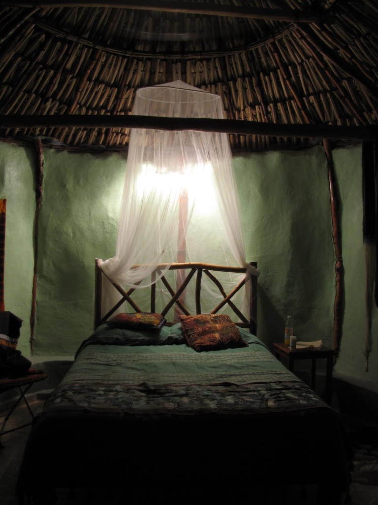
Our room contained both a western-style bed (with netting) and a hammock, the latter of which is the preferred bedding for many locals and the cooler option on warm nights. Unfortunately for us, we were not particularly adept at sleeping in hammocks, and our first night was tortuously uncomfortable due to the inescapable heat. In addition, we had to choose between using the mosquito netting over the bed—which helped to deter the small, black, biting insects that made their way into our sheets at night—or the overhead fan, because the manufactured breeze could not penetrate the lightweight canopy. Eventually, though, we accepted our bug-bitten fate, chose the fan, and finally fell asleep.
The temperature the next day—like most days—was in the 90s, and we ended up relaxing in the well-kept pool after an intense several hours of exploring ruins. Thankfully, the evening finally cooled off and our room became perfectly comfortable. We slept hard that night, and only reluctantly rolled out of bed (late) the next morning.
The only other unpleasant aspect of our time at the Pickled Onion, aside from our hot and buggy first night, was the appearance of moldy fruit in our breakfasts both mornings. This may sound nitpicky—and probably is, given that the rest of our food, even the rest of the fruit, was either good or excellent. At the time, though, we were already on our guard about all things food related, and had specifically been warned about eating the skins of uncooked fruits and vegetables. While never enticing, the repeated discovery of mold was especially off-putting in this context of food-paranoia, and made us nervous about everything else we consumed there. Fortunately, it turned out that such worries were needless, as we never got sick from anything we ate or drank at the B&B.
Now back to the good stuff. In addition to the hammock, our room contained a number of thoughtful details, including decorations of locally made crafts and a fridge (which, even when turned off, was useful for storing food without attracting bugs). My favorite touch, however, was the binder Valerie put together with descriptions of nearby sites, important information about the rooms (toilet paper goes in the trash; tipping is encouraged; to-go lunches need to be ordered the night before; etc.), and a short autobiography explaining how she came to own a bed and breakfast in Santa Elena.
All things considered, we would definitely stay at the Pickled Onion again, although preferably in the cooler months. The restaurant is open to non-guests in the evenings, so if you are in the area, even if you stay at another hotel, I strongly suggest getting your dinner (and a mojito) here.
X’batún cenote. Photo by Renée DeVoe Mertz/Joshua Albers, May 22, 2015.
We said goodbye to Mérida on the morning of our fourth day and headed towards the heart of the ancient Puuc region, where we would spend the next two nights. Before diving into our next archaeological adventure, however, we took a slight detour to the X’batún and Dzom-Bacal cenotes. These swimming holes, located about halfway between Mérida and Uxmal off Highway 261, are popular spots for locals, and we shared our time there with families and elderly couples alike.
Bees and their honeycomb at X’batún. Photo by Renée DeVoe Mertz, May 22, 2015.
Despite a general lack of signage, we eventually found our way to the check-in point in San Antonio Mulix, where we paid and used the small bathrooms to change. Unfortunately, it was also here that our poor knowledge of Spanish finally bit us in the bum. I had read in another traveler’s blog that we would have the option of leaving our car there and renting a bike to take the rest of the way. We thought this meant cars weren’t permitted past the check-in point, making walking or biking our only options. Since I don’t ride, we chose to walk, despite the fact that it was dangerously hot and the cenotes were well over a mile away. [Note: Google Maps claims it is only a 0.1 mile, two minute walk to X’batún; that is WRONG.] As we started out, every person we passed looked at us like we were crazy—which we probably were—but we just smiled in return and kept plodding towards our destinations. Eventually, a concerned man came down from one of the few structures along the way to ask why we were going by foot. After a little back and forth, we finally understood that cars are permitted by the cenotes, leading us to very gratefully turn around and get ours.
Wasps’ nests clinging to the limestone outcroppings at X’batún cenote. Photo by Renée DeVoe Mertz, May 22, 2015.
X’batún is the better known of the two cenotes, perhaps because it is the easier one to photograph, with bright, blue-green water dotted with lily pads and filled with colorful fish. The swimming area is partially surrounded by cliffs—from which long tree roots and wasp nests picturesquely hang—and partially by an open, limestone landing where visitors can enter the water. This short descent is still a little treacherous, however, due to the slippery vegetation that covers the submerged steps and rocks closest to shore. During our visit, one of the older visitors took what looked and sounded like a nasty fall on these stones (although that did not deter him, after a dazed moment, from staying and playing with his friends).
A sampling of the many fish living in X’batún cenote. Photo by Renée DeVoe Mertz, May 22, 2015.
In contrast, the swimming area in Dzom-Bacal is located almost entirely beneath a limestone outcropping and is barely visible to visitors as they walk down the long staircase into the cenote. The cave-like surroundings keep the water particularly cool and blue, with very little flora growing on or between the rocks. Floating in the giant, liquid sapphire, we watched the few tiny fish swim around us while swallows darted back and forth in the low space above our heads. It was an incredibly beautiful experience, and one of the most serene moments of our trip.
Dzom-Bacal cenote. Photo by Renée DeVoe Mertz, May 22, 2015.Dzom-Bacal cenote. Photo by Renée DeVoe Mertz, May 22, 2015.
If you go—to these or any other cenotes—remember to not wear sunblock or other lotions, as these will wash off and harm the natural flora and fauna. Large hats and long sleeves are therefore imperative for protecting yourself when out of the water, and the time spent in well-lit swimming holes, like X’batún, should be limited.
Having spent the morning at Dzibilchaltún and the Gran Museo del Mundo Maya, we returned to Mérida’s city center to drop off the car and take a short break at the hotel before walking to our next destination, the Canton Palace Museum. Also known as the Museo Regional de Antropología, the mansion-turned-museum blends early 20th century opulence with archaeological artifacts and, sometimes, more contemporary art. During our visit, the downstairs was closed for installation, but the upstairs hosted an exhibition on Puuc architecture that included relief details from Uxmal and other related sites, as well as quite a few illustrative photographs and explanatory text. Although visually the exhibition could not, of course, compare with seeing the works in situ, the written content was extremely informative, with clearer explanations for the development and significance of Puuc architecture than I have seen elsewhere.
Our visit was brief—around 30 minutes—and I remember being disappointed in the museum on the whole. Our guidebooks had been rather gushing in their praise for its collection, and the reality felt significantly less impressive, especially after having just seen the Gran Museo del Mundo Maya. It also didn’t help that we were nearing the end of a day spent in nearly relentless heat, including a long walk through the congested (if sometimes scenic) sidewalks of Mérida to get there. Looking back, however, I primarily think of the quality of the scholarship and the beauty of the mansion itself. We also appreciated the exhibition more when we went to Uxmal just two days later and were able to mentally place some of the architectural details we had seen in the Canton Palace on the buildings from which they are now missing.
Highly subjective personal rating: 6.5/10 [probably 7/10 or higher when both levels are open]
Between Dzibilchaltún and Mérida’s city center sits the strikingly contemporary building of the Gran Museo del Mundo Maya. Built in 2012 in the shape of an abstracted ceiba tree (which in Maya mythology unites the three levels of the world), the museum expertly combines a vast collection of artifacts with up-to-date technology and display techniques, including immersive, multi-channel animations.
The Gran Museo divides its gallery spaces into two physically separated sections. During our visit, the first held an exhibition that was both innovative and straight-up weird. We never did figure out exactly what the thesis of the show was supposed to be (something related to evolution or extinction or how different cultures interpret the natural world?), but it included information on meteors as well as living, imagined, and extinct animals using geological fragments, fossils, European Renaissance prints, replicas of Maya artifacts, and a life-size installation representing the extinction and evolution of dinosaurs. Despite the jumble of ideas apparent throughout this section, most of the actual objects were interesting, while the unusual juxtapositions between seemingly unrelated items kept us engaged as well as confused.
Even so, I will admit to being relieved when we entered the second section, dedicated to Maya history and the museum’s permanent collection of artifacts. These galleries alone are well worth a visit to the Gran Museo, as they include a plethora of fascinating objects, many of which diverge significantly from what you can find in textbooks or even specialist publications on Maya cultures. Also refreshing were the explanatory texts, many of which appear in Spanish, Mayan, and English and reflect a perspective that somehow feels both personal and scholarly.
Highly subjective personal rating: 8.5/10 [strongly recommended]
On the morning of our first full day in Mérida, we hopped back in the car and headed north of the city to Dzibilchaltún.
Located on a hot, dry plain about 22 km south of the coast, Dzibilchaltún has the honor of possessing the least picturesque ruins of the 20-plus Maya sites we visited. However, what the destination lacks in architectural or decorative splendor it makes up for in historical importance and, thanks to its cenote, natural beauty. The on-site museum—which consists of both indoor and outdoor displays of artifacts, stelae, and anthropological installations—is also quite good and added significantly to our appreciation of the site.
First occupied around 800 BCE, Dzibilchaltún was one of the earliest major settlements on the peninsula. As a result, some of the oldest known ceramics of the region come from here. The local economy was based on salt trade, and the relative strangeness of the city’s location—which is both inhospitable and fairly far from the sea—can be understood as a compromise between finding land that was capable of supporting a minimal amount of agricultural cultivation while simultaneously as close to the salt-producing coastal lagoons as possible. Of course, the presence of a cenote, offering fresh water in an otherwise arid environment, would have been a key factor in the choice of locale as well.
At one end of the traversable ruins stands the site’s most iconic building, the Temple of the Dolls. Named for the seven, rough, ceramic figures once buried in front of its altar and now on display in the museum, the temple sits in near isolation at one end of a large, open plaza. Doors located at the center of each of the sanctuary’s four walls heighten the effect of the square building’s rather unusual radial symmetry, while skeletal remnants of Chaac masks sit above these entrances and at the roofline’s four corners. Like many surfaces at the site, the masks (and numerous nearby stelae) were once covered in sculptural, painted stucco. Archaeologists have discovered graffiti inside the temple as well, some of which may date to 1200–1520 CE, when Maya pilgrims reopened and restored the sanctuary. Unfortunately, the building itself is no longer accessible and must be appreciated from a distance.
Running east-west, a long, straight sacbe connects the Temple of the Dolls to Dzibilchaltún’s central square. Visitors can either follow this road to the rest of the site or walk along a parallel (and more shaded) path part of the way. Those who take the sacbe will also pass another, circular trail that leads to very little.
The central plaza consists of a few, spread-out structures, including a small pyramid, an open Franciscan chapel, stone bleachers, and a gateway. On the other side of the gateway lies the Xlacah Cenote, perhaps the site’s greatest highlight.
Swimming is allowed, albeit “at your own risk,” but there is no changing room or shower on the grounds.
As an oasis in an otherwise parched landscape, the water here is teeming with life. During our visit, the pool seemed especially hospitable to lily pads and various fish, the latter of which struck us as a little too eager to swarm a bit of flesh and check it for possible food. We spent the majority of our time at Dzibilchaltún admiring the cenote and its surrounding flora and fauna, but left the swimming for another day.
Although I don’t imagine myself returning to Dzibilchaltún, the cenote and museum alone made it worth a visit. If you go, arrive early to beat the tourist groups bused in from Mérida. There is no escaping the sun, so having a hat, sunblock, and plenty of water is especially important here.
It was already late afternoon by the time we escaped Balankanché, prompting us to once again skip the cenote on the day’s itinerary and drive straight to our next hotel. This time we were headed to Mérida, the capital and largest city of the state of Yucatán.
Driving and parking in central Mérida is not fun—the roads are narrow, mostly one-way, and frequently filled with cars as well as pedestrians spilling over from the equally crowded sidewalks. Many hotels will have special deals worked out with specific lots, and it helps to know ahead of time which parking lot is affiliated with your hotel. Otherwise, look for the estacionamento signs (sometimes simply indicated by an E in a red circle), find one near where you will be staying, and just know that you will pay for an hour or so before you can come back and move your car to the appropriate lot.
Once you’re settled-in, the city will reward your effort to be there. At least for a day or two. Mérida is home to good shopping, numerous restaurants, a few solid museums, and faded glories of colonial architecture. It also lies in proximity to a number of Maya ruins (day trips to the World Heritage sites of Chichén Itzá and Uxmal are available from the city) as well as to the sea. As a result, the city is a popular stop for cruise lines, and during the day many tourists will come ashore to acquire relatively inexpensive, locally made goods, including jewelry, masks, wide-brimmed hats, embroidery, and other textiles. Even Josh and I, who had not planned on shopping at all, ended up contributing a fair amount to the local economy.
I should probably note here that Americans and Europeans often feel taken advantage of in Mexico, especially in larger cities like Cancún and Mérida. Sometimes such feelings are the result of misunderstandings born out of overlapping but ultimately very different cultural economics. Sometimes they are the result of one person actually taking advantage of another. As a foreigner, you are certainly a target for vendors and guides who rely on the money of tourists for their own survival. That can get very old very fast, especially as you hear the same lines again and again. For instance, nearly everyone claims that what they sell is “authentic” and that everything sold everywhere else is “fake.” Without being an expert myself on Maya goods, I can only advise that whatever you hear—from angry tourists and hungry vendors alike—take it with a grain of salt.
After finally checking-in to the hotel, the friendly guy attending the front desk pointed us towards a nearby collective, where, he claimed, proceeds from sales were redistributed to all of the participating artists in an effort to support the local communities as a whole. True? Nope. That is, not according to the many fuming reviews I have since read on TripAdvisor. But at the time, trusting both our hotel and the seemingly sincere man we met at the store itself, we ended up purchasing a few pieces of opal jewelry (mostly as gifts) for decent prices. Were the stones authentic? I fear the answer to that is also nope, despite the certificates accompanying each piece. One of these days I will screw up my courage and have mine appraised, but in the meantime I’ve decided to just enjoy them both as the pretty trinkets they are and as the gentle reminders of the fallibility of my own judgement they have become.
On our second night, we allowed another man to draw us into his store for jipijapas (aka, Panama hats, made from jipijapa palm leaves), hammocks, and clothing woven with sisal. In addition to being light, strong, flexible, and breathable, the fibers of both the palm and sisal are supposed to possess properties of a natural bug repellant—all highly desirable features during a Yucatán spring. Unlike most touristy items, such products are actually popular with locals, and the hats especially were essential wearing for anyone working in the sun.
We chatted with the owner for a while, and as we tried on items he showed us pictures of himself and his associate as a child and young man, respectively, working in the caves where jipijapas are made. He explained that manipulating the fibers requires the damp, warm environment of the caves, just as the finest weaving on the top of the hat requires the small hands of children and women. Because of the poor air quality, hat makers can only remain underground for a few hours a day.
I think he told us all of this to illustrate the communal nature of his store, to convince us of the specialness of the hats, and to illustrate why they were worth the amount he was asking for them (the equivalent of about $40 each). Outwardly, we tried not to disappoint him with our reactions. Inwardly, the actual effect of his story was somewhat different. Having just spent an hour ourselves in a Yucatán cave, the idea of anyone, especially children, working in such conditions was wrenching. The realization that by purchasing the hats we would be supporting such a system was horrifying. And yet, if we didn’t buy anything, those same people would be that much worse off due to the lack of income from their labor.
Intellectually, of course, I know that we all participate in similarly fraught economic situations everyday. But as an American, it is rare to have the system laid so bare before you, to see so clearly how inescapable it is, or to be so close to the people most affected by the terrible dichotomy of life saving/life endangering work. I am still not sure what the right thing to do actually was.
In the moment, however, we chose the easier path of the more immediate good, and are now the (conflicted) owners of two very nice jipi hats.
Since returning home, I have come across a few reviews by scorned tourists challenging the notion that jipijapas are constructed in caves. I would love for that to be true. Unfortunately, as documented here, the practice seems to be alive and well, although in Becal such caverns may be man-made and not nearly so deep as the likes of Balankanché. Perhaps that makes all the difference? Or is that idea just another scam, one we try to sell to ourselves to make our own lives a little more comfortable?
Incensors around a naturally formed column representing the Ceiba, or World Tree, Balankanché. Photo by Renée DeVoe Mertz, May 20, 2015.
Over the course of my various travels, there have been five moments when it occurred to me that I had put myself in a situation where I might die. The first took place in London, during a late night stroll along the bank of the Thames. The second was in Taiwan, sitting at the front of a bus making its way down the winding sliver of a cliffside road inside Taroko Gorge. The third and fourth were both in planes during storms, one while flying through the edge of a typhoon over the Pacific, the other in a much smaller aircraft over the Midwestern United States. And the fifth instance happened this spring, during a tour of Balankanché caves.
Located about 4.5 km southeast of Chichén Itzá off highway 180, the site of Balankanché had been used, off and on, since at least the Late Preclassic (300 BCE—250 CE) until the fall of Chichén. As a sacred site, the many clustered, in situ artifacts consist of implements for rituals. Incense burners—several of which possess semi-abstracted faces—are particularly, and unusually, abundant.
The cave itself is essentially T-shaped, with the central passage culminating in a chamber dominated by a naturally forming column and stalactites that together resemble the trunk and hanging branches of a great, subterranean tree. To the Maya, this formation represented the World Tree, or Ceiba, which connected the three layers of the universe: heaven, the middle (terrestrial) world, and the underworld. The raised ground around the bottom of the “tree” is heavily dotted with incensors and may have been used as an altar.
Having grown up in an area similarly situated on limestone, and thus similarly punctuated by caves and sinkholes, I was particularly excited by the possibility of visiting this site. However, my experiences with the cool environments of caverns in the US colored my expectations of what the Yucatán counterparts would actually be like. Despite having read that the air would be warm and humid, and that the “major danger” archaeologists faced “during the exploration was lack of oxygen,” my brain somehow never accepted what this had to mean for our own visit until we were actually in the tunnels themselves [Coe 2001, 399].
We arrived at the site after spending the morning and early afternoon in the sun at Chichén Itzá. Fortunately, the air conditioning in the car had already provided some much welcome relief from the heat and helped revive our energy for this next adventure. Upon our approach, though, we learned that we were the only people at the welcome center, and the next tour wasn’t scheduled for another 45 minutes. Waiting was a gamble, as the site’s policy is to only take groups of five or more into the caves; if no one else came, we would have wasted our limited time. Spurred on in my enthusiasm by wishful optimism, I assumed more people would show up closer to the time of an actual tour, and so we opted to wait. And then, when the tour time came and went and still no one else had arrived, we waited a little longer. Finally, after almost an hour and a half, we decided to leave and try to salvage the rest of our afternoon by visiting the nearby Ik Kil cenote. As we got up to leave, the man supervising the site stopped us and offered to let us go if we paid for two extra people. We agreed, albeit a little reluctantly, and he called over one of the guides to take us through.
At this point, I was a little annoyed. After all, there were three guys, including our own guide, who had been waiting the whole time we were there to lead people into the caves. Surely, I thought, it was better for them to take two people rather than no one at all. Making us wait and then pay extra felt a lot like getting fleeced. But we had already invested the time, and not going would have been the second major disappointment of the day. So we sucked it up and determined to make the most of the opportunity we had.
Our guide was perfectly pleasant, although he spoke very little and led us quickly through rising and falling tunnels. At first I wished he would slow down so we could better take-in the surroundings; 20 minutes later, I wished we could somehow go even faster. His job was not so much to provide information or guidance (the piped-in dramatic voices near the entrance and installed electrical lighting did that) as it was to occasionally draw our attention to the major points of interest within the caves. It was also, I soon understood, to make sure we didn’t somehow get lost or pass-out.
There is only one entrance into the caves, which means that there is only one source of fresh air. As we made our way further underground and further from this opening, the atmosphere became steadily hotter and more humid. Eventually, it felt as if we were walking through water, and I found myself unable to get enough oxygen into my lungs. Stopping did not help. The only way to get the O2 I so desperately wanted was simply to keep walking until conditions improved. The effect lessened somewhat—although not enough to breathe comfortably—when we reached the Ceiba, and we paused there (for as few minutes as possible) to take pictures. We then went a little further into one of the branches of the “T,” but my memories of what we saw are hazy at best. I do recall, however, my intense relief when I realized we were heading back and my even greater relief when we stumbled out into the open air. There were several moments, both going and coming, when I had to suppress waves of panic, and I was thankful to have both Josh and our guide there. Knowing that they, too, were having trouble breathing reassured me that the issue was environmental and not personal (ie, I was not having a heart attack) and that if we just kept going we would make it through.
Even so, it took several hours after leaving the site for the squeezing sensation in my lungs to go away and for my breathing to return to normal. I’m also embarrassed to say that although we finally appreciated the reasonableness of their five-person minimum policy, in our lightheaded, respiratory desperation and general desire to escape the site, we forgot to tip our guide. This was the worst tipping mistake of our trip, and the one thing I most wish we could go back and change.
Ultimately, although I am glad we went, I don’t foresee ever returning to Balankanché and would only recommend it to the physically sturdy with a strong interest in Maya culture and archaeology.


 masks decorating the roofline of one side of the \"Nunnery's\" courtyard-facing walls, Uxmal. Photo by Renée DeVoe Mertz, May 23, 2015.")


 And so on.


, Uxmal. Photo by Renée DeVoe Mertz, May 23, 2015.")


 the House of the Turtles, ballcourt, Nunnery, and Magician's Pyramid. Photo by Renée DeVoe Mertz, May 23, 2015.")


 chapel built from Maya masonry, Dzibilchaltún. Photo by Renée DeVoe Mertz, May 21, 2015.")


