Driving another three km east from Xlapak took us to Labná, the last of the ancient cities along the Ruta Puuc included within Uxmal’sWorld Heritage site. Labná is a bit smaller than Kabah and Sayil, and is one of the oldest cities of the region. The primary buildings, including the palace, gateway, and mirador (observatory), are notable not only for their unusually well-preserved state, but for being particularly emblematic of the Puuc style in both architecture and decoration, with myriad long-snouted masks, attached columns, step-and-fret designs, and even figural reliefs gracing their exteriors.
According to the entranceway plaque, Labná’s origins likely date “from around the beginning of our era,” although the remaining structures are the result of multiple building phases from 750 to 1000 CE. Like the other cities in this arid area, Labná depended on its ability to catch and store rainwater, which it did using nearly 70 chultuns (narrow, domestic cisterns) and a natural aguada (sealed depression in the land, similar to a cenote).
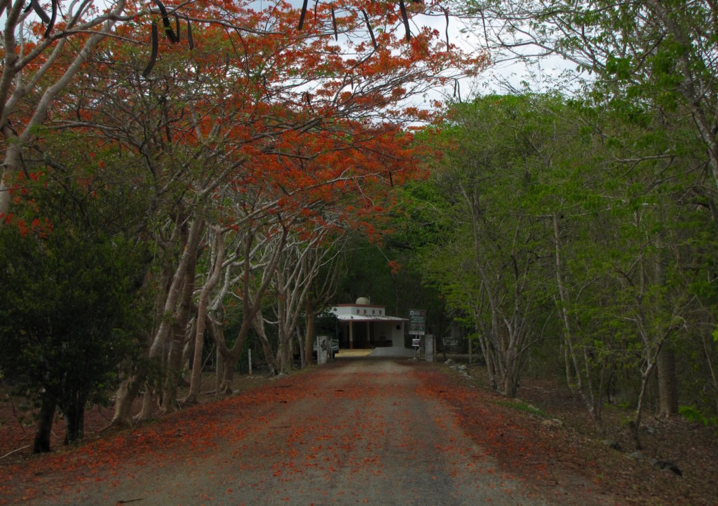
View of Labná’s palace from the southeast, with the connecting sacbe visible on the left.
The palace is the first major building visitors encounter within the archaeological area. Set on a platform and facing the sacbe that still connects it to the residential and mirador groups located directly to the south, this structure is the largest of several buildings that make up the “palace group.” Although shorter and less imposing than Sayil’s three-story version, Labná’s palace has the relative advantage of being more accessible and better preserved. And its many nooks and crannies do benefit by close inspection.
Long-snouted mask (center) and partial warrior statue (left) on Labná’s palace.Vaulted passageway joining two of the palace’s buildings.Long-snouted mask with remnants of red paint.Swallow living in a room of Labná’s palace.Detail of Labná’s palace showing head emerging from one of the most elaborate long-snouted masks of the region.Alternative view of the heavily decorated corner of Labná’s palace. Note the second human face at the base of the building, beneath the attached columns.
From the palace, visitors can take a path east to the “Edificio de las Columnas,” an L-shaped residential structure built in the Puuc Junquillo style, or walk south to Labná’s most distinctive feature: its gate.
West side of Labna’s gate decorated with mat designs and miniature huts.Step-and-fret motif on the east side of Labná’s gate.
As an imposing structure that simultaneously limited and permitted movement between two plazas, the gate would have both connected and demarcated the spaces of the residential group to the west of the sacbe and what was likely a ceremonial center to the east [ref. map]. Iconographically speaking, the western face is the more exciting façade, with its miniature huts flanking either side of the archway. Each hut’s niche once contained a brightly painted stucco sculpture of a seated warrior, remnants of which are still extant today. The blue-green headdress and red walls are especially visible in the niche to the right (south) of the central doorway.
Detail of the west side of Labna’s gate with El Mirador in the background. The niche within the miniature Maya hut contains red and blue-green paint where a stucco warrior used to be.A bluish, stucco headdress; red walls; and jutting support stone are all that’s left of the warrior who once sat within the right niche of Labná’s gate.
For us, the gate is also memorable as the place where, while trying to 123D Catch the exterior, Josh smacked his head, skinned his shin, and bruised his foot falling down a pile of rubble. The experience was a good reminder to stick to the better-worn paths or, at the very least, to avoid unsure footing while wearing sandals.
View from the “residential group” of the gate, el Mirador, and a particularly aggressive pile of rubble.
To the east of the gate stands el Mirador, a 20 meter, pyramidal heap of stones topped by a small temple with a giant roof comb.
El Mirador, Labná.
The many support stones on the south side of the comb are evidence of elaborate stucco work that once covered the front of the building and, like the archway, was probably brightly painted. Although we know from early descriptions that most, if not all, of this decoration consisted of human figures, very little of the original ornamentation has survived [ref. image]. Fortunately, it doesn’t take a great deal of imagination to understand that this area—which is still impressive in its denuded state—would have been spectacular in its original condition.
Western path through Labná. Part of the palace is visible on the lower right.
We eventually returned to the welcome center via a more shaded (and rather beautiful) path on the western side of the site before once again hopping into our car and heading to Loltun cave, our final archaeological stop in the region and of the day.
Detail of the Great Palace of Sayil. Along with Kabah and Labna, Sayil is one of three satellite sites included under the designated UNESCO World Heritage Site of Uxmal.
On day two of our Puuc Route adventure, we followed Highway 261 south for just under five km past Kabah, then turned left onto a narrow, unnamed road. After another five km of doubt, we came upon Sayil, our first destination of the day. Turning right (south) off the unnamed road, we drove beneath a canopy of bright orange and green foliage up to the parking lot.
After paying the modest entrance fee, visitors walk about 100 meters south to a clearing and the site’s most impressive structure, the Great Palace.
Western façade of Sayil’s Great Palace. The staircase, which once led to the top of the structure, is no longer accessible to visitors.
According to the accompanying plaque, this monumental, three-story structure was built in several stages during the Late Classic period, mostly from 800–1000 AD. By the time of completion, it contained over 90 bedrooms and eight chultuns, and could have housed as many as 350 people. Its primary function was probably to serve as living quarters for the city’s governing elite, but some rooms were likely used for storage or administrative purposes.
Plan of Sayil’s Great Palace. By HJPD.Frieze on the second level of Sayil’s Great Palace. The two upside-down “diving gods” are similar to those found at the coastal site of Tulum, and may represent the maize deity.Turquoise-browed motmot perched on the Great Palace, Sayil.
In addition to its palace and unusual trove of artifacts related to non-elite life, the sprawling grounds of Sayil are particularly valued for their avian diversity, attracting bird watchers and archaeology buffs alike. As we followed the sacbe through the rest of the visitable area, we were pleasantly surprised by the variety of fauna we encountered. The only place we saw a more diverse range of wildlife was at Calakmul, the massive, isolated site and nature preserve located over 300 km to the south near the border of Guatemala.
Highly subjective personal rating: 7.5/10
Great Kiskadee, Sayil.Butterfly at Sayil, tentatively identified as the “Gray Cracker” (Hamadryas februa).Stela with Yum Keep, the phallic god of male fertility. In comparison to other low-relief depictions of gods found on Maya stelae, the figure is unusual for its frontality and simplicity, as well as its lack of accompanying glyphs.Hooded oriole on the grounds of Sayil.Sayil’s Mirador Temple is in the early Puuc style, characterized by a high roof comb punctured with openings. The building was originally decorated on three sides, and support stones for now-vanished stucco work are still embedded on the south wall.Temple of the Hieroglyphic Jambs, Sayil. The building gets its name from the stone border around one of its doorways, seen here on the far right. Little of the original structure is left, and more than half of the remaining wall–along with its glyphs–is buried beneath the surrounding rubble.Detail of the visible glyphs on the Temple of the Hieroglyphic Jambs.
All photos by Renée DeVoe Mertz, May 24, 2015, unless otherwise indicated.
Statue on the east side of the Codz Poop, Kabah. Photo by Joshua Albers, May 23, 2015.
After a full morning at Uxmal (and much needed siesta at the Pickled Onion), we drove south-east to our next stop on the Ruta Puuc: Kabah.
As one of Uxmal’s closest and largest neighbors, Kabah was once connected to the larger city by means of a 30 km sacbe. Today, Highway 261 unites the sites. Visitors park on the west side of the modern road, then cross to pay the entrance fee and explore the remains of two palace-style structures.
View of Kabah’s east side. The Codz Poop is partially visible on the right.
From the guard’s office, we passed over the open field and climbed the raised platform on which the city’s temples and elite residences once stood. Towards the front of this low plateau sits Kabah’s best preserved and most ornate building, the Codz Poop [“rolled matting”], also known as the “Palace of Masks.”
Western façade of Kabah’s Codz Poop.Detail of the many Chaac masks on the Codz Poop’s façade.Chaac mask step at entrance to a room inside the Codz Poop.
As its nickname suggests, the Codz Poop is best known for the 250+ interconnected Chaac masks covering the west-facing façade. Although the lower portion of this wall remains remarkably intact, relatively few embellishments still grace the upper register. Instead, unassigned fragments of the modular faces—mostly upper and lower eyelids—sit in stacked pairs on the ground at the foot of the structure.
Pairs of eyelids in front of the Codz Poop.
Despite the façade’s partially ruined state, it’s easy to imagine that at its peak, when the wall of faces was not only intact but brightly painted and possibly decorated with hundreds of lights perched on the Chaacs’ long, angular noses, the effect would have been overwhelming, intimidating, and, ultimately, sublime.
Glyphs carved on the border stones of a small platform in front of the Codz Poop.
Viewing the same building from its east side, however, gives a very different impression. In contrast to the uniformity of the front, the rear decoration is clearly divided into lower and upper registers. The sections between the doorways are covered in the cross-hatching patterns of abstracted mats—from which the building gets its name—while the scant remains of the section along the roofline host two figures in the round. Although one of these warriors is now missing his head, both wore elaborate feathered headdresses, the depictions of which are clearly visible in low-relief on the stone wall behind the statues.
Warrior statues on the east side of the Codz Poop. Photo by Joshua Albers.
The militaristic theme continues on the late-9th century doorjambs located on either side of the east façade’s main doorway. Aside from their value as rare examples of highly legible, in-situ Puuc reliefs, the doorjambs are especially fascinating for the clues they provide (and questions they raise) about the history of the region. In addition to the inclusion of glyph dates between the upper and lower scenes of each jamb, the carvings also depict warriors possessing attributes associated with central Mexican cultures, including atlatls (spear throwers). Their presence is evidence of contact between the Toltec and Maya, and may suggest an early Toltec invasion of the Yucatan.
Southern doorjamb relief of warriors on the Codz Poop. The figure on the upper left holds an atlatl in one hand and darts in the other.Northern doorjamb relief of warriors on the eastern entrance of the Codz Poop. The figures on the upper and lower left each hold an atlatl and dart, weapons more typically associated with central Mexican cultures.
After taking in the second “palace” and carefully crossing back over the road, we followed the trail from the parking lot to a free-standing Maya arch that marked the beginning of the sacbe that connected Kabah to Nohpat and Uxmal. Aside from this one large but unadorned structure, most of the ruins on the west side of the highway, including Kabah’s great temple, remain overgrown and unreconstructed. Without a wealth of ruins to hold our attention, our focus shifted to other aspects of the landscape, including the hard-working dung beetles who shared our path.
Highly subjective personal rating: 7.5/10 [The Codz Poop is outstanding, but after Uxmal, the smaller site is bound to feel a little underwhelming by comparison.]
Arch and platform marking the beginning of the Kabah-Uxmal sacbe.
All photos by Renée DeVoe Mertz, May 23, 2015, unless otherwise indicated.
View of the “Magician’s Pyramid,” Uxmal. The curving edges of the pyramid are unique in Maya architecture, and may be the result of flawed restoration.
Of the many exceptional Maya ruins we visited in the Yucatán Peninsula, both Josh and I agree that Uxmal was our favorite. My notes from the half-day we spent at the site simply read “Uxmal=Amazing,” and that still pretty well sums up our impression of the ancient city.
Like Chichén Itzá, Uxmal is an UNESCO World Heritage site located within day-trip distance of Mérida. However, its more southwesterly position off a less trafficked route means that it is not as convenient a destination for cruise travelers or those staying in Tulum, and thus receives fewer visitors than its slightly more famous cousin. This is good news for those who do put in the small amount of extra effort necessary to get there, as it not only means you will be sharing the grounds with fewer people, but also that those other people usually care about what they’re seeing (a characteristic we didn’t fully appreciate until later, when we found it lacking among too many of the tourists populating the Maya Riviera).
Stacked Chaac masks decorating the roofline of the “Nunnery’s” north building. Although made up of modular stone units, each face is distinct. The “Venus Temple,” visible here in the lower register of the image, is named for the repeated “W,” or trident-shaped, designs on the façade that represent the planet Venus.
When traveling within the peninsula, moving south generally means moving back in time. Whereas the buildings at Chichén Itzá mostly date to the Post-Classic era (c. 11th-13th centuries CE), Uxmal is a Late Classic site, built primarily between the 7th and 10th centuries CE. It is the largest and most complex of the cities designed in the Puuc style, and one of the few Yucatan centers not near a cenote. Instead, the residents dug chultuns (deep, narrow cisterns) to capture rain water. The many masks that typify the stone latticework in Puuc architecture have long been thought to represent Chaac (Chac, Chaahk), god of rain, in part because rain would have been both relatively scarce and extremely important to the city’s survival.
[Note: According to a display at the Canton Palace Museum, some recent studies have suggested that these masks might be depictions of Witz, the sacred mountain, rather than the rain deity. However, another plaque located a few feet away in the same exhibition clearly takes the more traditional view that these are the faces of Chaac. Since the question is still contested, I am using the traditional identification of the masks as Chaac because it is both the more widespread view and the one most repeated at the site itself.]
Broken Chaac masks look out from the Nunnery towards the Magician’s Pyramid. The great, open-mouthed face at the top of the pyramid’s stairs is similar to the serpent mask doorways common in the Chenes-style architecture of the southern Yucatán.
Although more difficult to capture in photographs, the layout of Uxmal is almost as striking as its highly decorated architecture. After visiting Chichén Itzá and Dzibilchaltún, where the major buildings are spread out and emphasized through man-made horizon lines, the relationships between buildings in Uxmal can feel layered and compact despite the substantial size of the site. This is particularly true of the area around the Magician’s Pyramid. Even though the structure is one of the largest and most conspicuous monuments in the ancient city, the courtyard (known as the “Quadrangle of the Birds”) separating it from the buildings of the “Nunnery” is quite small—so small, in fact, that it is impossible to capture the entire front of the pyramid in a single photograph. This means that there are few opportunities to view the face of the pyramid as a whole. And yet, the building’s upper portion is one of the most visible and eye-catching sights in the city, with a giant, open-mouthed mask looking out towards the Nunnery and marking the entrance of the temple located at the top of the central staircase. Instead of opening the space around the pyramid so it could be easily understood as a whole, the city’s builders created multiple opportunities for visually framing, and thus drawing specific attention to, this mask.
Case in point:
And so on.
No other single feature stands out so dramatically at the site, especially when seen from a distance, suggesting that it was this part of the pyramid, rather than the totality of the structure, that held the most significance for the city’s residents. The doorway is also unusual for Puuc architecture, and appears to be a blend of local Puuc and southern Chenes decorative styles. For instance, the use of stacked Chaac masks (seen here at the edges of the central face) is a typically Puuc (and Chenes) feature, while Chenes architects frequently incorporated open-mouthed serpent masks around the doorways of important buildings. In fact, the closest known parallel may be at Hormiguero, one of the most far-flung of the Chenes-style sites, located nearly 300 km away in the south of the Peninsula.
Chenes-style structure at Hormiguero in southern Campeche. The masked doorway is similar to that on the Magician’s Pyramid in both style (including the border of stacked Chaac masks) and central placement at the top of a high staircase.
Unfortunately, no one now knows exactly what Uxmal’s structures, including the Magician’s Pyramid, were used for. The city had long been abandoned by the time the Spanish arrived and christened the buildings with names based on their own initial impressions of the site. However, modern scholars have noted that Uxmal’s layout appears to follow astrological features, particularly the movements of the sun and Venus. The cycles of both celestial bodies played definitive roles in Maya conceptions of time, but how that translated into the uses of these buildings is still largely a matter of speculation.
The unfortunately named Nunnery, located near the site’s entrance beside the Magician’s Pyramid, is a slightly asymmetrical complex with long, heavily ornamented buildings framing a large courtyard. The light show, held in the evenings just after dusk, takes place here, with the audience sitting in folding chairs near the top of the northern building.
Northern building of Uxmal’s Nunnery with the Temple of Venus on the left.Western building of the Nunnery.The Nunnery’s eastern building.View from the Nunnery’s north building, looking out over the south building at the Governor’s Palace, House of the Turtles, and Great Pyramid.
Most scholars believe that both the layout and decorative façades of the Nunnery possess dense symbolism. The buildings themselves may have formed a mandala of the Maya universe, with the tall, north building embodying the Upper World; the short, southern building representing the Underworld; and the east and west buildings standing for the rising and setting aspects of the Middle World (Coe 360). If correct, the complex—built toward the end of Uxmal’s peak—was a physical declaration of the city’s place at the center of the universe.
In addition to the ubiquitous Chaac masks, the courtyard-facing imagery includes repeated depictions of double-headed or feathered serpents, Maya huts, jaguars, and even masks of Tlaloc, the goggle-eyed water deity associated with central Mexican cultures. The cross-hatching designs, common throughout Uxmal, depict mats, emblems of power.
Stack of Chaac masks in Uxmal’s Nunnery, topped by the goggle-eyed image of Tlaloc.Relief of a Maya hut on the south building.God N, the elderly lord of the Underworld, appears above the central entrance of the west building of Uxmal’s Nunnery. He is depicted with the face of an old man and body of a turtle beneath a feather canopy.
From the Nunnery, we walked through the small ballcourt, past the stepped hill supporting the Governor’s Palace, over the Dovecote, and up the Great Pyramid.
Unlike the Magician’s Pyramid, the Great Pyramid’s 100 feet of steps are still open to those visitors who are willing to climb them. Which we did.
Josh chasing his hat down the Great Pyramid (taken from below the halfway point), Uxmal.
In addition to offering a view of the city’s central buildings, the platform at the top of the pyramid supports a small temple decorated with macaws—perhaps representing an aspect of the sun god—and more long-snouted masks, some of which hold human heads in their mouths. Only one side of the pyramid has been reconstructed, and it is not possible to enter the temple proper.
The northeast corner of the Great Pyramid abuts the man-made hill that forms the platform for the Governor’s Palace (or House of the Governor) and House of the Turtles. Walking around the narrow south end of the Palace leads to an open plaza that faces the front (east) side of the building.
Approaching the Governor’s Palace from the southeast.
Near the center of the plaza, directly before the Palace’s staircase, stands an altar supporting Uxmal’s two-headed jaguar throne. Excavations revealed a large cache of over 900 objects, including pots, jade jewelry, and obsidian knives, buried beneath this altar (Coe 360). Although we were unaware of it at the time, Coe also notes that an invisible line corresponding “to an important point in the Venus-cycle” runs from the central doorway of the House of the Governor, through the throne, to the largest structure at the nearby site of Nohpat (361). This relationship between the two cities is further emphasized by the fact that they were once also directly connected by a sacbe (white road).
From the plaza, it becomes clear that the Palace is in fact three separate buildings connected by spear-point arches and unifying visual features, including one of the most intricate friezes of the region. Altogether, the buildings run for over 100 meters, making the three-part unit one of the longest palace-style structures of any Maya city. Visitors can walk up yet another platform to approach and look into these buildings, but are not supposed to enter them. The rooms currently hold unassigned architectural fragments and serve as cool-ish resting places for iguanas.
The northern corners of the Palace have been dug out to reveal more Chaac masks sunk below the walkway. Their strange placement may indicate that the patio area around the structure represents a later building stage than the rest of the House of the Governor.
Excavated corners of the Governor’s Palace, revealing Chaac masks.View from the north side of the Governor’s Palace, looking down at (from left to right) the House of the Turtles, ballcourt, Nunnery, and Magician’s Pyramid.
Descending from the Palace, we approached the House of the Turtles, located at the northeast corner of the hill-platform.
Some scholars have proposed that the House of the Turtles, named for the row of 40-plus stone turtles encircling the upper portion of its roof, may have been dedicated to a rain “cult,” since turtles are associated with rain. If that is the case, however, it raises the questions of why no images of Chaac adorn the building, especially given the proliferation of the god elsewhere at the site (there are over 100 such masks on the Governor’s Palace alone), and why one of the only other depictions of turtles in the city is clearly attached to the god of the underworld (see image of God N relief at the Nunnery, above).
The relative austerity and small size of the building complements the ornate enormity of its neighbor. Its exterior is punctuated by 10 doors: three each on the east, west, and south walls and just one in the north. Another sight-line leads from the central doorway on the south wall, through the northern opening, across the ball court, to the central entrance of the Nunnery’s south building.
Sight-line from the House of the Turtles to the Nunnery.View of the ballcourt, House of the Turtles, and Governor’s Palace.
For our last stop, we walked west to the “Cemetery Complex,” which, in keeping with the misnomers that abound at the site, is not an actual cemetery. Named for the numerous images of skulls and cross-bones carved on the low platforms dotting its main square, the Complex includes a heavily overgrown pyramid and temple platform. Much of the western area has yet to be reconstructed and is thus far less spectacular than the eastern side of the site. Even so, this quiet group offers the rare opportunity for close inspection of in situ, fairly well preserved reliefs that make it another not-to-be missed section of an already remarkable place.
Highly subjective personal rating: 10/10
Bonus pics:
Back of the Magician’s Pyramid as seen from the path connecting the visitor center to the ruins. A bit of the Nunnery’s north building is visible on the right.One of the palace-style buildings in the Quadrangle of the Birds. The square gets its name from the bird reliefs decorating the stone roof of this structure.Turquoise-browed motmot.The narrow, colonnaded structure located to the southwest of the Magician’s Pyramid is neither on our maps nor mentioned in either guidebook. I have no idea what it is.One of Uxmal’s many photogenic iguanas.


 After paying the modest entrance fee, visitors walk about 100 meters south to a clearing and the site’s most impressive structure, the Great Palace.


 masks decorating the roofline of one side of the \"Nunnery's\" courtyard-facing walls, Uxmal. Photo by Renée DeVoe Mertz, May 23, 2015.")


 And so on.


, Uxmal. Photo by Renée DeVoe Mertz, May 23, 2015.")


 the House of the Turtles, ballcourt, Nunnery, and Magician's Pyramid. Photo by Renée DeVoe Mertz, May 23, 2015.")


